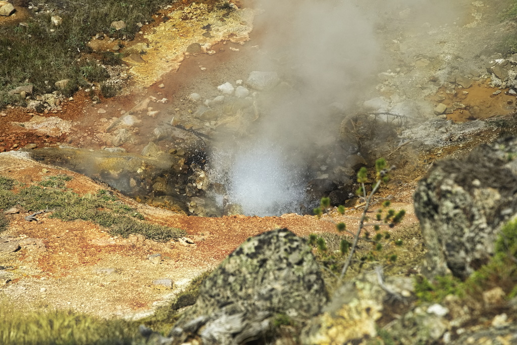
re: Yellowstone Fumarole - submitted by ghostsniper in Comments
Yellowstone Park sits directly over a hot spot. The volcano is quiet today, only the geysers and hot springs remind us that there is an enormous volcano under the beautiful scenery. Just 600,000 years ago a huge eruption filled the area with lava flows. After the enormous eruption there was a void under the top of the volcano. The weight of the volcano caused the top to come crashing down forming the large Caldera in the park. Since the hot spot remains active, another giant eruption will almost certainly occur. The question is, when?
A new cycle of volcanic activity has begun. The number and strength of earthquakes have increased; new hot springs have appeared and existing ones have grown. A large area to the northeast of Yellowstone Lake has uplifted. Will it erupt again? If so, when? How much damage will it cause?
Not until the thermal imaging units were installed in satellites in the nineties was the scientific community aware that calderas existed. They were simply too large to be seen with the naked eye or any known instruments before that time. It was then that the vast size of the Yellowstone caldera became apparent. On the order of 600 miles by 400 miles scientists were stunned to realize the magnitude of the forces it contained.
Imagine one of those Betty Crocker dinners. You pour a packet of vegetables into the Pyrex then you dump a can of gravy on it. Then you spoon dollops of gooey dough on top of that, then into the oven at three-fifty for an hour. When its done you have a crispy roof over a boiling vat of gruel. If you poke a hole through the roof the gruel will ooze up from below. This is a Caldera.
The earth is seven-tenths water so it is in keeping that most of the worlds Caldera’s are underwater. The largest known Caldera is located approximately four thousand miles west of California in the center of the Pacific ocean and it is called Panthea. Less than one hundred feet below the surface of the sea bottom the temperature of Panthea is estimated at over eight thousand degrees. Steam regularly is emitted from hundreds of surface orifices over Panthea and the surface is constantly moving.
Panthea is estimated to be over two hundred and fifty miles in depth and nine hundred miles in diameter, the largest of all Calderas. Tied to the San Andreas fault on the United States western seaboard Panthea is considered the origin for most of the seismic activity in this region as well as in Alaska and eastern Asia including Japan, China.
Recent readings of Panthea’s core temperatures indicate that changes are occurring as the surrounding waters escalate in temperature. Biologists are plotting computer models to try to determine what the ripple effect will be if the caldera roof would collapse due to liquification. The first sign would be Richter machines going off the scale, on the order of fifteen point oh. This alone would disturb the very mantle of the earth itself. Second, the collapse in volume of the earths surface, the ceiling of the caldera, would cause huge tension release within the oceans body. Think of a large plate of spaghetti with suddenly no plate. When the structure of the ocean floor itself is removed, it is not clear what exactly will happen in other parts of the world.
Suddenly the oceans water would sweep into the new void created by the caldera. This water must come from somewhere, it would come from everywhere simultaneously. Like pouring cold coffee down the kitchen sink. Gone. The level of the seas would drop six feet in a matter of minutes and coastlines would be scrubbed as massive volumes of seawater were pulled toward the void. Millions of people worldwide would be swept along with the rushing seas. Entire cities would vanish, coastlines too would no longer exist.
Panthea is roughly the size of the Gulf of Mexico, but two hundred and fifty miles deep. This space would consume large amounts of both the Pacific and Atlantic oceans. In hours the level of the worlds oceans would drop more than 100 feet. Icebergs in the Arctic sea would topple as they touched the sea bed, the Mediterranean sea would be dry. Hydrostatic vacuum would cause all buildings on all coasts to collapse.
As trillions of gallons of seawater drain into the gaping boiling Panthea the water will be instantly heated to eight thousand degrees creating a gaseous explosive mixture of thousands of chemicals simultaneously. The blowback from this will shower the stratosphere worldwide.
Matt Rense is a thirty four year old construction superintendent who lives in the town of Crystal Bay outside Chesapeake, Virginia with his wife Sarah and their two kids Jarrod and Sensia, ages 10 and 8. Sarah is a teacher in a private school named Colloquial First where their kids attend. Matt has a past time as an Ultralight pilot and this may be the key to evacuating his family to safe ground further inland from the coast of their home as pandemonium reigns all around them.
Continue reading →