Lenticular Cloud
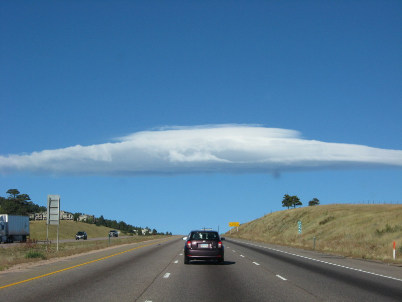
illinoisbeekeeper took this photo Oct 4, 2014. I-70, MP 255 west of Denver.
Now, for extra bonus points – which way is he headed ?

illinoisbeekeeper took this photo Oct 4, 2014. I-70, MP 255 west of Denver.
Now, for extra bonus points – which way is he headed ?
He’s goin’ thata way.
Well, let’s see…even numbered interstates run East-West.
Odd numbered run North-South. So, that cuts our options by half.
MM sign on I-70 west of Denver defines location and leaves two choices for direction: east or west. John Venlet got most of the answer.
“thata way” ? cute but not overly informative IMHO.
I know it’s east or west because even road number.
OK, so you offered a bonus-points challenge and I went for it. I found the Colorado DOT Mileage Marker map and that places Mile Marker 255 between Mt. Vernon and Genesee. I spent the better part of 30 minutes with the Google Maps Little Blue Man moving along I-70 in both directions looking for the 255 Mile Marker, those 3 trees on the right and the buildings on the left. The Little Blue Man is limited by any traffic which may obscure signs, and try as I might, I couldn’t find those landmarks.
But, if you’re in Colorado in October, the sun is south of directly overhead. And you can see that the shadow coming off the car in front of you is to the right, which would be the northern side of the car.
I am 95% certain that you were headed west.
Do I get a cookie?
Sounds good to me. Need verification from illinoisbeekeeper but the shadows indicate westbound. Figured someone would catch that.
I didn’t want your cookie to go stale in transit, so I ate it as I thought of you.
🙂 🙂 🙂 !!!
We were headed W
Here a google maps link to the exact spot
https://www.google.com/maps/@39.7049658,-105.2685441,2260a,70.3y,258.8h,95.38t/data=!3m7!1e1!3m5!1sfR2fllCrWvwdsileKLDYcA!2e0!6shttps:%2F%2Fstreetviewpixels-pa.googleapis.com%2Fv1%2Fthumbnail%3Fcb_client%3Dmaps_sv.tactile%26w%3D900%26h%3D600%26pitch%3D-5.383853699680856%26panoid%3DfR2fllCrWvwdsileKLDYcA%26yaw%3D258.80324666089473!7i16384!8i8192?entry=ttu&g_ep=EgoyMDI2MDkwOS4wIKXMDSoASAFQAw%3D%3D
A bit further in ( W ) is the ‘Buffalo Overlook’, there are reportedly Bison in that park to the N of I-70. Ben thru there 10 or more times, never seen any.
https://www.google.com/maps/@39.711071,-105.2958492,2358a,75y,312.96h,75.94t/data=!3m8!1e1!3m6!1sCIABIhCAzahZ9SekThuNzMqXMBAF!2e10!3e11!6shttps:%2F%2Flh3.googleusercontent.com%2Fgpms-cs-s%2FAFP8RcNRbk0vbPF8-YUxjrlS3Efdf80sdgEsseWRvIeIkZk_kFIL03DHJIABrNPJEuCedkJEeUl7QlBBy6GefhLegJdRwOSkX7mgcFFYYsHoT4PRRlQjjIGMqKatUfdPn_kwfaTQN3_AaOSkJkE5%3Dw900-h600-k-no-pi14.060138334249586-ya309.7151262942615-ro0-fo100!7i7680!8i3840?entry=ttu&g_ep=EgoyMDI2MDkwOS4wIKXMDSoASAFQAw%3D%3D
I’ve seen them but I lived in the area and that was 30 years ago. On the other side of the highway in that area stood the “Sleeper” house. Once standing isolated in the trees – but easily visible. I understand that area’s now developed and the house (if it still exists) is hard to see.
If west of Denver and no mountains in the background then you are headed east.
Heading up into the hills west of Denver (and Golden), there are places where the mountains are difficult to see … even though only a few miles from the Divide. This is a Giggle shot at the Lookout Mtn exit (mm256). Heading west.
Always an exception to the logical rule! Thanks sir!