Once upon a few decades ago, I was a member of a volunteer fire dept. Most of us had moved into the area at roughly the same time and we just kind of merged into a group protecting our neighborhood - said neighborhood consisting of well over 800 acres - roughly 1½ sq miles - on the side of a mountain ranging from 3200 ft to 5000 ft of deep Ponderosa pine forest and twisty mountain roads not much better than two-track dirt.
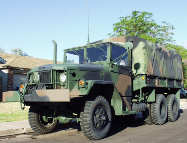
When we started out, one could fairly call us a yahoo outfit, a bunch of us not really knowing what we were doing with a couple of military surplus deuce-and-a-halfs as equipment; one tender, one pumper.
I loved driving these things.
We had good leadership and it didn't hurt that the National Interagency Fire Center was located in Boise - about 45 miles away - with one of their main training bases in Idaho City, even closer. The result was we went from know-nothings rambling around the neighborhood and adjoining areas to becoming state and federal qualified personnel within a certified fire tax district with proper equipment. Still have my wildland gear including a long out-of-date potato sack. I think I still have my "red card" floating around here somewhere. Couldn't qualify for it today.
But this is background. I may come up with more fire dept tales but this tale isn't about the fire dept.
You get tight-knit with people you risk your life with. We covered everything from kitchen fires to large-scale campaign forest fires. We also acted as the local rescue squad so we got involved with almost every emergency in an area over 100 sq miles; some quite dangerous, some quite funny. Some quite heart-breaking. One develops a weird sense of humor.
Being in a forest surrounded by flames is as much an interesting experience as busting into a burning house looking for survivors - or victims. Never alone; always trusting your partner to have your back.
Being in the type of environment we existed in, there was rarely a chance to "save" anyone or anything; it could take close to an hour and 50 or more road miles to get to some of the emergencies. It wasn't uncommon that we could do no more than prevent a spread. "We saved the log pile" was not an uncommon result.
You know? Watching a 1000gallon propane tank blow from 40 feet away is a sight to behold and an experience to remember. Luckily, they tend to blow up, not out.
I came back some time after leaving the dept - I had a job in another state - and met up with Terry at a dept get-together.
"Hey, Terry! How ya doin'; whacha been up to?"
"Oh, I just got back from back east"
"Where'd you go?"
"Kentucky"
"Hey, I was just back in Kentucky myself. Where in Kentucky?"
"Oh, some little town you never heard of - xxx"
"Why I know xxx; my family comes from around there. Why would you be there?"
As it turned out, Terry had been born in xxx and never knew it. His mother left his father while she was pregnant, moved to LA, got re-married, and the new husband adopted Terry as an infant or maybe while Mom was still pregnant. Gave Terry his last name as well. Must have also changed his birth certificate. Terry was raised a California boy as "Terry AAAA"; never knew his father was really his step-father.
Two of his half-brothers back in Kentucky - that he wasn't aware of - had died in a car accident and someone tracked him down and told him about it. He went back for the funeral and found that his birth name was actually "Terry BBBB".
Now we get to the strange part. Terry's brothers were buried up on a ridge between two hollers. One of those hollers was settled by my umpteenth great grandfather and was named for my family. Terry's brothers were buried in a joint family cemetery; one of the families was mine. Furthermore, in that cemetery was buried his remote ancestor that had first settled that ridge back in 1800 or so and who was buried next to his wife - one of my umpteenth great aunts who died in childbirth. Her child survived and was one of Terry's ancestors.
Now back in small-town Kentucky, you're "family" even if the connection goes back to 1810. The husband of one of my cousins knew Terry's birth family quite well and filled in quite a bit of Terry's earliest history. Our families were a bit inter-twined.
So here we are - Terry & I - meeting each other as members of a small rural fire dept in backwoods Idaho, finding we're (distant) cousins from back in Kentucky.
Terry was quite embarrassed to find he was by birth a Kentucky hillbilly rather than California sunshine surfer boy. Not too many people know, the original group of firefighters have dispersed - including me, and Terry doesn't speak of it.
When I was still in touch, I'd invite him to family reunions "back up the holler". I don't think he's ever returned.
Continue reading →