"Democratic Socialist Rep. Rashida Tlaib (D-MI) was triggered this week by a Homeland Security post on X featuring a B-2 stealth bomber overhead and a cowboy below, accompanied by the text in the center of the image that read:"We'll Have Our Home Again.""
"What does it evoke in you when you see this? Literally, when I see it, as a Muslim, as a Palestinian, as a child of immigrants, I see it as something that evokes the feeling that I'm not welcome here"
"She called herself "a Muslim, a Palestinian, a child of immigrants" and doesn't even bother to call herself an American."
Don't let the door hit you on the ass on your way out.
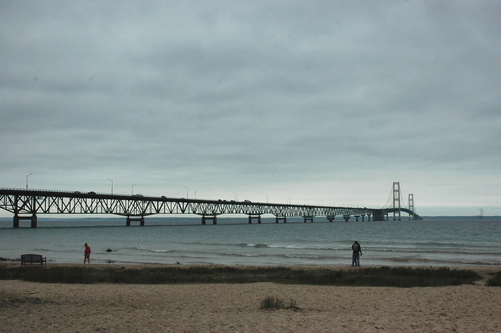
Fort Michilimackinac on the south shore (northern tip of the lower peninsula) was an early 1700s French, then British, fur-trading fort. The French had settled the area in the mid-1600s and the fort was a significant player in the French-Indian war of the 1750s. The British took over from the French in 1760 even though the residents of the region were mostly French. The area was also involved in Pontiac's War in the mid-1760s. In 1781, the British abandoned this fort and re-established another on Mackinac Island. The old fort was burned upon abandonment; a replica is now a state park just below the bridge (the "new" fort, Fort Mackinac, is now a museum on Mackinac Island). The British kept Fort Mackinac for 13 years after the Revolutionary War when it became American territory . This fort was a player in the War of 1812 and was kept as an active Army post until 1895.
Opened in 1957, the Mac connects the Upper and Lower peninsulas of Michigan across the Mackinac Strait (which connect Lake Michigan to Lake Huron) via 4 lanes of I-75. Mackinaw City (settled 1673; pop about 800) is on the south side of the bridge; St Ignace (settled 1671; pop 2300) is on the north. I-75 extends another 50 miles and ends at Sault Ste Marie at the Canadian border. Mackinac Island is just to the east of St Ignace. Before the bridge was built, ferry service transported traffic across the Strait. Ferry service stopped the day the bridge opened.
The bridge - shoreline to shoreline - is 5 miles long and over 550 feet high (at the towers; the road is 200 feet above the water; the water is 250 feet deep at the bridge center) and is the longest suspension bridge (between anchorages) in the US. (Golden Gate is longer between towers; the Bay Bridge has an anchorage in the middle).
The bridge is a toll bridge ($4 for cars), one of three sections of I-75 that has tolls (one at the Canadian border, the other at the other end in Florida). The bridge is only open to pedestrians on Labor Day; it is not open to bicycles. Two of the lanes are closed to traffic on that day. Suicides are rare - perhaps a dozen in the life of the bridge. The bridge is not in a highly populated area.
The two outside lanes are paved; the inner two lanes are open grid. A 2ft median separates the two directions.
There is enough fear of crossing the bridge that an extra service is available to have a "driver's assistance" program in which someone will drive your car across for you. About 1,000 people per year request this service (of about 4 million crossings per year - deer hunting season!).
In 1959, an Air Force pilot flew his B-47 under the bridge - he was grounded for life.
The bridge occasionally closes due to high winds and icy conditions (ice falling from the cables).
Note: "Upper Michigan" is the northern part of the lower peninsula; the upper peninsula is the "U-P", inhabited by "Yoopers".
Sometimes I miss my home state ... not so much as I'd return though.